Georgia’s geographic location and natural features have played a powerful role in shaping its economy, infrastructure, and global connections. Whether referring to the U.S. state of Georgia or its strategic positioning within the southeastern United States, geography has been a major factor in transforming Georgia into a hub for trade, transportation, logistics, and commerce. From deepwater ports and extensive rail networks to highways, rivers, and access to international markets, Georgia’s geography provides distinct advantages that support economic growth.
This in-depth guide explores how Georgia’s geography supports trade and transportation, examining its location, physical features, transportation infrastructure, and strategic advantages that make it one of the most important commercial centers in the region.
Georgia’s Strategic Location in the Southeastern United States
One of Georgia’s greatest strengths is its strategic location. Positioned in the southeastern United States, Georgia serves as a natural gateway between the eastern coast, the southern states, and the Midwest.
Georgia borders:
- Tennessee to the north
- North Carolina and South Carolina to the northeast
- Florida to the south
- Alabama to the west
- The Atlantic Ocean to the east
Access to Major Domestic Markets
Georgia’s geography places it within a two-day truck drive of a large percentage of the U.S. population. This proximity allows companies to move goods quickly and efficiently to major markets such as:
- Florida
- Texas
- New York
- Illinois
- Ohio
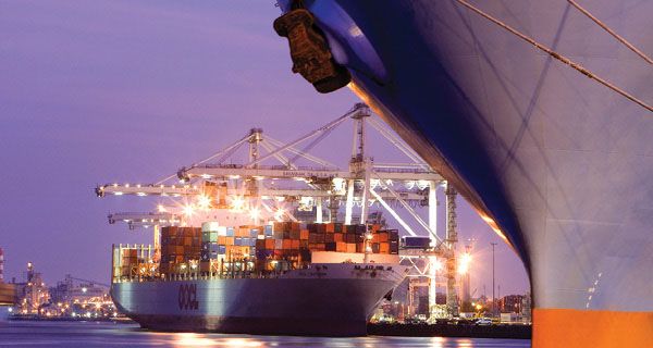
Coastal Geography and the Port of Savannah
Georgia’s access to the Atlantic Ocean is one of the most important geographic features supporting trade.
The Role of the Atlantic Coastline
Georgia’s coastline, though relatively short compared to some coastal states, provides direct access to international shipping routes. This coastal access allows goods to move efficiently between the United States and global markets.
The Port of Savannah
The Port of Savannah is one of the busiest and fastest-growing container ports in the United States. Its geographic location makes it a key entry and exit point for global trade.
Key advantages of the Port of Savannah include:
- Deepwater access for large cargo ships
- Proximity to major highways and rail lines
- Efficient cargo handling and storage facilities
- Direct shipping routes to Europe, Asia, Africa, and South America
- Import of consumer goods, machinery, and raw materials
- Export of agricultural products, automobiles, and manufactured goods
Rivers and Inland Waterways
Georgia’s river systems have historically played an important role in trade and transportation.
Major Rivers in Georgia
Georgia is home to several major rivers, including:
- The Savannah River
- The Chattahoochee River
- The Flint River
- The Ocmulgee River
Rivers as Economic Pathways
Although modern trade relies more heavily on roads and rail, Georgia’s rivers still support:
- Industrial water supply
- Hydroelectric power
- Commercial shipping in certain regions
Flat Terrain and Transportation Development
Georgia’s physical geography includes a large area of relatively flat land, especially in the Coastal Plain and Piedmont regions.
Advantages of Flat Land
Flat terrain makes it easier and more cost-effective to build:
- Highways
- Railroads
- Airports
- Warehouses and logistics hubs
Support for Road and Rail Networks
Because of its terrain, Georgia has been able to develop an extensive and efficient transportation network that supports large-scale trade and distribution.
Georgia’s Highway System and Interstate Connectivity
Georgia’s geography has supported the development of one of the most extensive highway systems in the southeastern United States.
Major Interstates in Georgia
Georgia is intersected by several major interstate highways, including:
- Interstate 75 (north-south)
- Interstate 85 (northeast-southwest)
- Interstate 20 (east-west)
- Interstate 16 (linking Atlanta to Savannah)
Atlanta as a Transportation Hub
Atlanta’s central location within Georgia and the Southeast has made it a major transportation hub. The city serves as a crossroads where multiple interstate highways converge, allowing goods to move efficiently in all directions.
This highway connectivity supports:
- Trucking and freight transport
- Distribution centers and warehouses
- Retail supply chains
Railroads and Freight Transportation
Georgia’s geography also supports a strong rail transportation network.
Importance of Railroads
Railroads have long been critical to Georgia’s economy, particularly for transporting heavy and bulk goods such as:
- Agricultural products
- Coal
- Automobiles
- Manufactured goods
Rail Connections to Ports
Railroads connect the Port of Savannah to inland markets, making it easy to move goods from ships to trucks or trains. This intermodal connectivity is a key factor in Georgia’s role as a logistics powerhouse.
Air Transportation and Global Connectivity
Georgia’s geography also supports air transportation, particularly through its major airports.
Hartsfield-Jackson Atlanta International Airport
Located in Atlanta, Hartsfield-Jackson Atlanta International Airport is one of the busiest airports in the world. Its central location allows it to serve as a major hub for both passenger and cargo flights.
Key advantages include:
- Direct flights to domestic and international destinations
- Rapid movement of high-value or time-sensitive goods
- Strong connections to road and rail networks
- Technology
- Medical supplies
- E-commerce
Climate and Year-Round Trade
Georgia’s moderate climate is another geographic advantage.
Favorable Weather Conditions
Georgia experiences relatively mild winters and long growing seasons. This climate:
- Reduces weather-related transportation disruptions
- Supports year-round farming and production
- Allows ports, roads, and rail systems to operate efficiently most of the year
Agricultural Trade Benefits
Georgia is a major producer of agricultural products such as:
- Peanuts
- Poultry
- Cotton
- Fruits and vegetables
Georgia’s Proximity to Natural Resources
Georgia’s geography places it near important natural resources that support trade and industry.
Forests and Timber
Large forested areas provide timber for:
- Construction
- Paper products
- Manufacturing
Agricultural Land
Fertile soil across much of Georgia supports farming, which feeds into trade networks both domestically and internationally.
Georgia as a Logistics and Distribution Center
Georgia’s combined geographic advantages have made it a leading logistics and distribution center in the United States.
Why Companies Choose Georgia
Businesses are drawn to Georgia because of:
- Proximity to ports
- Highway and rail access
- Central location in the Southeast
- Efficient transportation infrastructure
Economic Impact of Geography on Trade
Georgia’s geography does more than support transportation—it drives economic growth.
Job Creation
Trade and transportation support jobs in:
- Shipping and logistics
- Manufacturing
- Warehousing
- Trucking and rail operations
Global Trade Connections
Georgia’s geographic position allows it to connect U.S. businesses to international markets, strengthening exports and imports.
Challenges and Geographic Limitations
While Georgia’s geography offers many benefits, there are also challenges.
Urban Congestion
Heavy traffic in metro Atlanta can slow transportation and increase costs.
Coastal Vulnerability
Ports and coastal infrastructure may face risks from hurricanes and rising sea levels.
Despite these challenges, ongoing investments continue to strengthen Georgia’s transportation systems.
The Future of Trade and Transportation in Georgia
Georgia continues to invest in infrastructure improvements to maximize its geographic advantages.
Expansion Projects
- Port expansions to handle larger ships
- Highway upgrades
- Rail improvements
- Airport modernization
Final Thoughts: Georgia’s Geography as an Economic Advantage
Georgia’s geography plays a vital role in supporting trade and transportation. Its strategic location, coastal access, navigable rivers, flat terrain, extensive highway and rail networks, and favorable climate all work together to create an efficient and powerful transportation system.
By connecting local producers to national and international markets, Georgia’s geographic advantages have transformed the state into a major center for commerce, logistics, and global trade. As infrastructure continues to expand and improve, Georgia’s geography will remain one of its strongest economic assets for generations to come.